 One of the most experienced individuals regarding swimming across the Catalina Channel is the indomitable Forrest Nelson. A one-way crossing, a two-way crossing, summer time crossings, winter-time crossings, observing, escorting, feeding and supporting, Forrest has done it all.
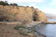
The most reasonable and recommended straightest tangent between Catalina Island and the Southern Californian mainland is between Terranea Beach (the old Marineland Pier location) and Doctor’s Cove on Catalina Island just west of Emerald Bay.
“At Palos Verdes [on the California mainland], Long Point is actually the closest spot, which is obscured by a kelp forest,” explained Forrest. “Instead, better choices are Terranea Resort beach to the east – with plenty of available parking and an easy walk down to the public beach – or what local call “Heart Attack Hill” to the west of Long Point, but still east of Pt Vicente. This point has parking and a very long and steep climb to the beach.”
If an athlete finishes on the mainland, Forrest also recommends Terranea Beach. “I lean toward Terranea, unless the currents get pushy and then it’s the “best option” depending upon how the swimmer is making due…. If it’s pushing toward Long Beach, the peninsula offers lots of options for a finish. A strong current pushing west will potentially sweep a swimmer away from an easy finish spot– meaning it’s often necessary to crab into stronger currents to get the swimmer to land.
Have a great weekend.
—–Original Message—–
From: Hank Wise
Sent: Aug 24, 2010 9:54 PM
To: Greg Wise
Cc: forrest nelson , Steven Munatones , fjwise@cox.net
Subject: catalina channel swim federation navigation recommendations
greg – you may want to print these navigation recs and become familiar with the coordinates…thanks – HW
The simplest and most frequently used form of navigation in open water is line of sight navigation. Assuming you can see your destination, you keep the boat pointed at it until you get there. This is very simple, but from the point of view of the swimmer, it is very inefficient.
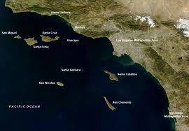
The ideal course of a swim across the San Pedro Channel (as the Catalina Channel is more properly known) would be a straight line, representing about 21 statute miles. However, the usual breeze from the west will steadily push the escort boat to the east, resulting in a curved course for the line-of-sight navigator. For example, if the wind is ten miles an hour, the curve in the course of a line-of-sight navigator would cause a fast swimmer to swim for about an extra hour. For a slow swimmer, the increase would be even greater.
Hand-held GPS receivers are easily obtained, and get cheaper all the time. By using GPS to navigate, you can maintain a straight-line course; the position information allows the prompt course corrections necessary to keep a swim on track.
A GPS receiver will show your precise location on the surface of the planet, your latitude and longitude. For example, just off the beach south of Point Vicente (a good place to start or end a Catalina swim), the GPS might show:
N 33° 44.213′
W 118° 22.780′
These letters and numbers are the latitude and longitude of a position 33 degrees, 44.213 minutes north of the Equator, and 118 degrees, 22.780 minutes west of Greenwich, England. (If you are not used to using circular or spherical coordinates, units of degrees and minutes may seem strange. It is, however the international standard. A circle is divided into three hundred and sixty degrees, and each degree is divided into sixty minutes. Using these units, one circle around the earth to the north and south, and one to the east and west allows accurate determination of any position on the surface of the sphere known as Earth.)
You will need a good map, which generally means a nautical navigation chart. The U.S. National Oceanic and Atmospheric Administration (NOAA) distributes charts for U.S. waters, including the San Pedro Channel. Along the top, bottom, and sides of these maps are latitude and longitude markings. You use these markings to plot your position, based on the readings from the GPS receiver.
Across the top and bottom of the NOAA chart for the San Pedro Channel there are markings for 117° 30′, 118°, and 118° 30′. Between these markings there are markings every five minutes (05′, 10′, 15′, etc.) Between each of these there are bars representing each individual minute and then markings for each tenth of a minute. Across the sides of the chart there are markings for 33° 20′ and 33° 40′, with markings for each individual minute and tenth of a minute.
To plot the position N 33° 44.213′, W 118° 22.780′ on the chart, draw a straight line down from 118° 22.780′ and another straight line across from 33° 44.213′. Where the two lines meet is your position.
At the start of the swim, use the GPS receiver to find your starting position, and plot it on the chart. Then draw a straight line from your starting point to the intended finishing point. As the swim proceeds, use the GPS to find your position every half hour, and plot each position on the chart. If your position does not fall on the straight line you drew, then you know that you are off course, and can make a course correction. If you do this every half hour, the swimmer will only swim a few extra yards instead of extra miles.
Copyright © 2010 by Steven Munatones